Dogs are permitted in the campgrounds and on all of the trails at Golden Gate. They must be on a 6-foot leash at all times. Please keep Golden Gate beautiful and pick up after your dog. Being a courteous and responsible pet owner can help you keep wildlife wild and be considerate of other visitors. Local wildlife is easily disturbed by out-of-control pets, so keep them on a leash. Your pet may also be very friendly when it meets other people or pets, but remember that that other person or pet may not like being approached by your pet or could even be aggressive towards your pet. Thank you!
There is NO cell phone or internet service in Golden Gate Canyon State Park. Payphones are located at the Visitor Center and Campground office.
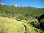
Over 35 miles of hiking trails in the park offer pleasures and challenges for everyone. The twelve trails at Golden Gate Canyon are each named after an animal and marked with a two letter abbreviation that corresponds the that animal.
Limit your impact while visiting Golden Gate Canyon State Park by sticking to designated trails. Social trails can be formed with as few as 10 visitors veering off the established trails. If the trail is muddy, don’t walk around the mud. This can result in the trail widening and lead to other erosional and recreational impacts.
Trail head parking areas are easily accessible from the main roads in the park. Please only park in designated areas and limit any impacts to vegetation.
 Mountain bikes and horses are permitted in the park on multiple-use trails. Ample parking space for horse trailers is provided at the Nott Creek trail head located near the Red Barn Group Picnic Area and at Kriley Overlook above Kriley Pond.
Golden Gate Trails
Download a Golden Gate Canyon Trails map.Permitted users: Hikers only
Total distance: 2.3 mile loop
Usage: Moderate
Degree of difficulty: Most Difficult
Starting elevation: 8,200 feet
Elevation gain: 685 feet
ADA accessible: No
Comments: Starts at Slough Pond. Trail takes you through Aspen groves and open grassy areas. Provides great views of Indian Peaks Wilderness Area, The Continental Divide, and Tremont Mountain. Trail branches off to the Beaver backcountry shelter.
Permitted users: Hikers only
Total distance: 2.5 miles one way
Usage: High
Degree of difficulty: Most Difficult
Starting elevation: 8,200 feet
Elevation gain: 1,135 feet
ADA accessible: No
Comments: Starts at Ralston Roost trail head. Some bouldering is required at the beginning of the trail, cairns help to mark the trail through this section. The trail reaches a summit at mile 2.25. The trail opens up at Rim Meadow, providing views of Mount Evans and Golden Gate Canyon. Ends at the Mule Deer trail.
Permitted users: Hikers, horse and mountain bike
Total distance: 0.8 miles one way
Usage: High
Degree of difficulty: Moderate
Starting elevation: 8,200 feet
Elevation gain: 287 feet
ADA accessible: No
Comments: Trail head at Kriley Pond Overlook to Mule Deer trail. Passes through a small aspen grove. Good short hike for young children.
Permitted users: Hikers, horse and mountain bike
Total distance: 1.2 miles one way
Usage: Medium
Degree of difficulty: Moderate
Elevation gain: 478 feet
ADA accessible: No
Comments: Starts at Rifleman Phillips parking area. The trail takes you past several historic buildings, aspen groves, and seasonal streams. It is the access trail for backcountry shelter #3 and the Forgotten Valley backcountry camping area. The trail ends overlooking the Tallman Ranch and Forgotten Valley. Intersects the Mountain Lion trail.
Permitted users: Hikers only
Total distance: 4.1 mile loop
Usage: Moderate
Degree of difficulty: Difficult
Starting elevation: 7,860 feet
Elevation gain: 1,140 feet
ADA accessible: No
Comments: Begins at Bridge Creek trail head. The trail is shaded by Aspen, Willow, Adler,and Blue Spruce trees. At mile 2.6 you have the option of climbing to Windy Peak, where you have a 360-degree view of the mountains. Trail intersects the Mountain Lion trail.
Permitted users: Hikers only
Total distance: 2 miles one way
Usage: Moderate
Degree of difficulty: Most Difficult
Starting elevation: 8,860 feet
Elevation gain: 621 feet
ADA accessible: No
Comments: Trail head at Bootleg Bottom. This is an access trail to the Frazer, Rim, and Greenfield Meadow backcountry campsites. The trail starts in evergreen forest and scattered aspen groves. This trail has some steep gains, loose rocks near the crest of Promontory Ridge requires caution. Trail opens out at Frazer Meadow. Intersects the Mule Deer trail.
Permitted users: Hikers only
Total distance: 1.8 miles one way
Usage: Very High
Degree of difficulty: Moderate
Starting elevation: 8,140 feet
Elevation gain: 927 feet
ADA accessible: No
Comments: Starts at Frazer Meadow trail head, a short drive from the Visitor Center. This well shaded trail is edged by seasonal streams and is full of wildflowers in the spring and early summer. At mile 1.10 a spur trail leads to Greenfield and Frazer Meadow backcountry camping areas. At mile 1.3 another spur trail takes you to the Rim Meadow backcountry camping area. The trail passes through aspen groves and fern-covered understory. One of our most moderate hikes. Meets the Mule Deer trail at mile 1.8.
Permitted users: Hikers, horse and mountain bike
Total distance: 6.7 mile loop
Usage: High
Degree of difficulty: Difficult
Starting elevation: 7,720 feet
Elevation gain: 1,602 feet
ADA accessible: No
Comments: Starts at Nott Creek trail head, off Crawford Gulch Road. The longest trail in the park, Mountain Lion takes you through undulating hills, open meadow, aspen groves, and dense evergreen forests. At mile .6 a service road provides access to the Burro trail. At mile 1.3 follow a steep spur trail for half a mile to the old quarts quarry. Mountain Lion also passes through the Deer Creek backcountry camping area. Take a detour at the Windy Peak (mile 3.6) or City Lights Ridge (mile 5.4) spur trails for 360-degree views of the surrounding mountains. Buffalo trail intersects Mountain Lion at mile 4.7, providing access to the Forgotten Valley backcountry camping area. A challenging ride or hike, with great pay-offs.
Permitted users: Hikers, horse and mountain bike
Total distance: 8.8 mile loop
Usage: Medium
Degree of difficulty: Moderate
Starting elevation: 8,200
Elevation gain: 1,394 feet
ADA accessible: No
Comments: In 2012, the Elk trail and Mule Deer trail will join up to become one 7.4 mile loop. Starting and ending at the Ole' Barn Knoll trail head, Mule Deer weaves through open meadows, evergreen forest, wildflowers, and aspen groves. Mule Deer intersects the Horseshoe trail at mile 1.85 - this trail provides access to the Frazer, Rim, and Greenfield Meadow backcountry areas. This is a perfect choice for horse riders; park your trailer at the Kriley Overlook, and access Mule Deer via the Blue Grouse trail. Mule Deer intersects the Black Bear trail at mile 1.5, and the Coyote trail at mile 2.05. The trail crosses Gap Road and takes you towards the Raccoon trail and the Reverend’s Ridge Campground.
Permitted users: Hikers, horse, and mountain bike
Total distance: 2.5 mile loop
Usage: High
Degree of difficulty: Moderate
Starting elevation: 9,120 feet
Elevation gain: 500 feet
ADA accessible: No
Comments: Trail starts behind the office at the Reverend’s Ridge campground, and passes through blue spruce, douglas fir, and groves of aspen trees, which are brilliant during the fall. Visit Panorama Point and enjoy spectacular views of the Continental Divide, before heading back towards your starting point.
Permitted users: Hikers, horse and mountain bike
Total distance: 3 mile loop
Usage: High
Degree of difficulty: Difficult
Starting elevation: 8,700
Elevation gain: 669 feet
ADA accessible: No
Comments: Trail starts at the Aspen Meadow campground and takes you past Dude’s Fishing Hole - a great place to sink a line and relax . You can extend your hike or ride by following the Mule Deer trail to Panorama Point- follow the spur trail near the end of the loop.
Visitor Center Show Pond Trail
Permitted users: Walkers only
Total distance: 0.25
Usage: High
Degree of difficulty: Easy
Elevation: starts and finishes at 8,200 feet
ADA accessible: Yes
Comments: This short interpretive walk around the Visitor Center show pond, provides information on local plant and animal life at Golden Gate. It is a nice way to break up your visit to Golden Gate. Picnic facilities make it an ideal location for lunch.
Visitor Center Nature Trail
Permitted Users: Hikers only
Total distance: 0.10 miles
Usage: High
Degree of difficulty: Moderate
Elevation: starts and ends at 8,200 feet
ADA accessible: No
Comments: A short interpretive hike behind the Visitor Center, identifying the different plants at Golden Gate.
Reverend’s Ridge Nature Trail
Permitted Users: Foot
Total distance: 0.25 miles
Usage: High
Degree of difficulty: Moderate
Elevation: Starts and ends at 9,200 feet
ADA accessible: No
Comments: Interpretive signs. Trail guide available at Reverend’s Ridge office.


