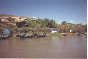
Yampa River boaters have 13 access points in the 134-mile-long Yampa River State Park portion of the river, stretching from Hayden, Colorado, to Dinosaur National Monument on the Utah border (permits required within Dinosaur National Monument). All access sites have some type of river access for boating or limited walk-wade fishing. Seven sites have developed ramps. Six of the accesses have camping with restrooms, hardened pads with tables and grills. The camping-area access sites have between five and 10 campsites, depending on the area. Many of these access sites allow you to float onto BLM lands which offer a primitive (undeveloped) camping experience along the way.
River Flow Classes
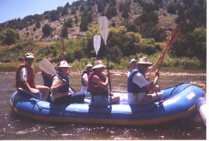
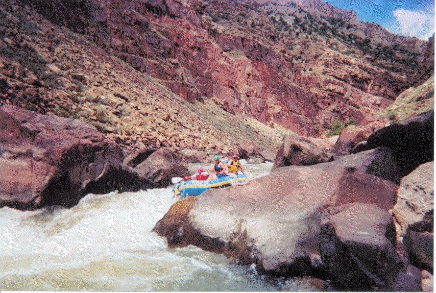
The river flow varies between Class I-II and Class V rapids. The majority of the Yampa River is Class I-II. with Juniper Canyon being III-IV, depending on flows. The Cross Mt. Canyon segment is class IV-V and can be impassible, depending on flows. In March and April, the flow averages 500 to 1,000 cubic feet per second (cfs). In May and June, flows reach 5000 to13,000 cfs. From late June through August, flows will drop to 500 cfs, and go up to 750 cfs in late September.
Depending on river flows, developed ramps may be closed for safety and legal reasons.
River Access Points With Boat Ramps
The Yampa River State Wildlife Area, which is managed by Colorado Division of Wildlife is your closest take-out. Downstream of the State Wildlife Area is the Craig Golf Course and then Loudy-Simpson Municipal Park. Both areas offer undeveloped access to river, with Loudy-Simpson having limited camping as well. Contact the Moffat County Parks for availability.
Following are descriptions of the seven Yampa River access points that have boat ramps, starting from the Hayden Pump Station access point and heading west to the Dinosaur National Monument. These sites - and the rest of the 12 access points (not all have boat ramps) - are identified by number in the Yampa River Map and Brochure.
Hayden Pump Station (1)
Hayden Station is located five miles east of Hayden at the power plant pump intake. This site has a developed boat ramp and toilet facilities, but it is a small area and not recommended for large vehicles. No camping is allowed at this site. Public lands are very limited downstream, so boaters need to be aware of private property. This site accesses some of the best bird-nesting habitat on the river. Please be very conscious of nesting birds and do not disturb them. This is a very unique stretch of river with a diversity of raptors and water birds as well as other wildlife. The downstream take-out is 11 miles, so plan accordingly.
Yampa River State Park Headquarters (2)
Yampa River State Park Headquarters is located 2 miles west of Hayden off Highway 40 on the south side of the highway. The headquarters site has boating access, campsites, a caper services building with showers/ laundry, a visitor center, and a nature trail. Camping is by reservation only.
South Beach (6)
South Beach is located three miles south of Craig on the west side of U.S. Highway 13. This site houses the water intake for Tri-State and Trapper Mining, so there are some parking and access restrictions. This site has good access to the river with limited primitive camping available. The camping is limited to a maximum two-night stay; camping permits are required. This area has restroom facilities, a boat ramp, day-use picnic sites and trash receptacles. This access site opens up a rare opportunity to float into “Little Yampa Canyon” and a stretch of river that is 32 miles to the next take-out. The downstream access is by boat only, so any vehicle use is extremely limited to access from private property or a few roads across BLM. Because of the remoteness of this area, trash and wastes must be packed out!
Duffy Mountain (7)
 Duffy Mountain is located 32 miles downriver from South Beach through Little Yampa Canyon and approximately 29 miles west of Craig. This is the primary take-out from South Beach. For river access at Duffy Mountain, take U.S. Highway 40 west approximately 19 miles from Craig. On the south side of the road, you will see County Road 17. Take County Road 17 south for approximately 10 miles. You will cross the Yampa River at a spot known as Government Bridge, no river access is allowed. Continue along the county road, following the signs for public access and go left at the cattle guard on BLM Road 1593.
This is a nice flat-water float, but check flow levels before starting. You will find a restroom, boat ramp, graveled parking area and a primitive camping/picnic site. This area of the river is great for wildlife viewing. Deer are abundant all year, and elk are visible during the winter. Look to the sky for soaring golden and bald eagles. Downstream access takes you into private lands, so take maps and do not trespass.
Juniper Canyon (8)
 Juniper Canyon is located 12 miles downriver from Duffy Mountain. To reach the access site at Juniper Canyon, take U.S. Highway 40 west out of Craig 20 miles to Moffat County Road 53, which is on the south (left) side of the highway. Take County Road 53 for 3.6 miles to County Road 74. Take a sharp right turn and drive approximately three-fourths of a mile to the site. This site has a developed boat ramp, restroom facilities, trash receptacles, and about a dozen primitive camping and picnic sites. Mountain bikers and hikers will enjoy great access to surrounding public lands. This area offers great wildlife viewing and fishing. Elk, antelope and mule deer roam the area. Hunters and OHV users have a great base camp opportunity here and can easily access public lands. Boaters need to be cautious of a class III-IV diversion dam downstream. A great wave train lines up below: Don’t miss the surf wave below the flume. After that, it is a nice mellow float out. A portage or scout above the diversion on the right is suggested.
Maybell Bridge (9)
Maybell Bridge is located 28 miles west of Craig on the south side of U.S. Highway 40. This access site is approximately 12 miles downriver from the Juniper Canyon access. A diversion hazard exists between the Juniper and Maybell sites (see Juniper description). This site has a boat ramp. There is limited foot access to the river. Primitive camping and picnic areas are along the river. There are restroom facilities and trash receptacles. This area offers great wildlife viewing. Deer and antelope are abundant throughout the year, and elk wander the area in the winter. This site is a great put-in for flatwater enthusiasts who like long distance day trips. Two undeveloped take-outs exist downstream. You can access a Division of Wildlife property via Moffat County Road 19. This will take you to the river north of Maybell or for a longer paddle. Go to the river access off of Hwy 318 at Sunbeam.
East Cross Mountain (11)
 East Cross Mountain is located approximately 18 miles southwest of Maybell. Take U.S. Highway 40 west of Maybell about 13.6 miles to Moffat County Road 85. Drive north on Moffat County Road 85 to the Bureau of Land Management Road 1551 and then 1.5 miles. Visitors should be aware that the road may be very rough. The improved site has a vault toilet, parking, camping/ picnic sites and a boat ramp. The area has tables and fire rings. State Park passes are required. This site accesses Cross Mt. Canyon and should NOT be floated by novice boaters.