Wolves in Colorado
Proposition 114, now state statute 33-2-105.8, passed on November 3, 2020. It directed the Colorado Parks and Wildlife Commission to develop a plan to introduce and manage gray wolves in Colorado west of the Continental Divide no later than December 31, 2023. Ten wolves were reintroduced to the state in December, 2023 as part of this plan.
Navigate to:

Monthly Collared Gray Wolf Activity June 23, 2026 - July 21, 2026
Map
Tracking Collared Wolf Activity
Colorado Parks and Wildlife’s Collared Gray Wolf Activity Map will help inform the public, recreationists and livestock producers on where wolves have been in the past month.
Notable Updates
- A highlighted watershed indicates that at least one GPS collared wolf was within that watershed during the month. It does not mean that wolves have traveled throughout the entire watershed or currently occupy it.
- Please note this map only reflects the activity of collared wolves and does not capture the activity of uncollared wolves
- CPW’s Wildlife Damage Specialists and wildlife managers are working closely with producers to proactively implement various conflict minimization tools and techniques on operations with localized wolf activity nearby.
- CPW has a number of resources for living with wolves available through our webpage for people living or recreating in areas with wolf activity.
Our staff continues to monitor all known wolves in Colorado, including the four packs, and will include a minimum count of the entire wolf population in our annual biological year reports. Receiving reports of wolf sightings from the public, especially those accompanied by high-quality photos or videos, is extremely helpful to CPW as we monitor and track the movement of gray wolves. This will become increasingly important as the population of uncollared wolves grows through successful restoration and natural immigration into Colorado.
Report the Take of Wolves
In addition to being federally protected, gray wolves are also a state-endangered species in Colorado, and wolves may not be taken (harmed, harassed, or killed) for any reason other than self-defense. The gray wolf in Colorado is protected by the federal Endangered Species Act (ESA) and state law. Penalties for illegal take can vary and include substantial fines, jail time and loss of hunting privileges.

Contact CPW
Anyone with information on the take of an endangered gray wolf in Colorado is encouraged to contact your local CPW office.
Find an officeCollared Wolf Activity Map
Tracking Wolves
Colorado Parks and Wildlife is implementing a thorough post-release monitoring program to assess and modify reintroduction protocols, if necessary, to ensure the highest probability of survival and site retention for released animals. All released wolves will be monitored using satellite GPS collars, which will inform managers on survival and dispersal, as well as future release protocols.
How GPS Collars Track Activity
Currently, collars are programmed to record a position every four hours. Once four locations have been recorded, the packet of four locations is then transmitted via satellite to Colorado Parks and Wildlife.
The frequency of both position recording and transmission of the data can be delayed by a number of factors such as dense cloud cover, closed terrain, etc.
By looking at the data, Colorado Parks and Wildlife staff can learn where wolves have been, but they cannot tell where wolves are at a current point in time, nor can they predict where the wolves will go.
Wolves with GPS Collars
As packs establish, effort will be made to collar at least one member of each pack with emphasis on breeding adults. The desired standard will be to have two collars in each pack; whether this is achievable for every pack in the state will be determined following reintroduction. It should be expected that through immigration from other states and natural reproduction of pups, the proportion of wolves that have collars will be reduced over time. Therefore, the accuracy of this map will be diminished over time as the activity of uncollared wolves may not be included in this map.
About the Map
A watershed is a geographic unit that drains water into a specific waterbody. Watersheds are the appropriate mapping unit to display wolf activity information because wolves are far more likely to use geographic features to affect their distribution than they are political boundaries.
These maps are created using GPS collar data collected from all collared wolves in Colorado. This includes animals reintroduced from Oregon and British Columbia, as well as wolves that naturally migrated in North Park.
In order for a watershed to indicate wolf activity, at least one GPS point from the wolf collars was recorded within the boundaries of the watershed. Simply because a watershed indicates wolf activity, it does not mean that a wolf or wolves are present throughout the entire watershed nor that they are currently in the watershed.
This map will be updated with new information on a monthly basis, produced on the fourth Wednesday of every month, and will reflect data for the prior month, give or take several days.
Wolf Activity Maps are produced using U.S. Geological Survey watershed information, frequently known as Hydrologic Units. The Hyrdologic Unit Code (HUC) 10 scale provides detailed information that can help agricultural producers be informed of the general areas where wolf activity is known to exist. Learn more about HUCs .
Map Archive
2026
- June 23, 2026 - July 21, 2026 (Download PDF)
- May 26, 2026 - June 23, 2026 (Download PDF)
- April 21, 2026 - May 26, 2026 (Download PDF)
- March 24, 2026 - April 21, 2026 (Download PDF)
- February 24, 2026 - March 24, 2026 (Download PDF)
- January 27, 2026 - February 24, 2026 (Download PDF)
- December 19, 2025 - January 27, 2026 (Download PDF)
2025
- November 25, 2025 - December 19, 2025 (Download PDF)
- October 21, 2025 - November 25, 2025 (Download PDF)
- September 23, 2025 - October 21, 2025 (Download PDF)
- August 26, 2025 - September 23, 2025 (Download PDF)
- July 22, 2025 - August 26, 2025 (Download PDF)
- June 24, 2025 - July 22, 2025 (Download PDF)
- May 27, 2025 - June 24, 2025 (Download PDF)
- April 22, 2025 - May 27, 2025 (Download PDF)
- March 25, 2025 - April 22, 2025 (Download PDF)
- February 25, 2025 - March 25, 2025 (Download PDF)
- January 21, 2025 - February 25, 2025 (Download PDF)
2024
- December 22, 2024 - January 21, 2025 (Download PDF)
- November 26, 2024 - December 22, 2024 (Download PDF)
- October 22, 2024 - November 26, 2024 (Download PDF)
- October 22, 2024 - November 1, 2024 (Download PDF)
- September 24, 2024 - October 22, 2024 (Download PDF)
- August 27, 2024 - September 24, 2024 (Download PDF)
- July 23, 2024 - August 27, 2024 (Download PDF)
- June 25, 2024 - July 23, 2024 (Download PDF)
- May 21, 2024 - June 25, 2024 (Download PDF)
- April 23, 2024 - May 21, 2024 (Download PDF)
- March 26, 2024 - April 23, 2024 (Download PDF)
- February 28, 2024 - March 25, 2024 (Download PDF)
- January 23, 2024 - February 27, 2024 (Download PDF)
- December 18, 2023 - January 22, 2024 (Download PDF)
Wolves in Colorado
Wolf Sightings
While we cannot validate every informal sighting, our staff carefully reviews all credible reports submitted through our Wolf Sighting Form. When credible reports of wolves are received, we work closely with our federal partners to investigate them. We will continue to work with USFWS and other state, local and NGO partners in sharing information regarding verified sightings with the public.
If you have seen a wolf, please complete the form below. When taking photos of a paw print for the sighting form, it is helpful to include an item next to the paw print and measurements of that item to help better identify the size of the track.
Tracking each confirmed sighting made sense in the past when wolves were not established in the state, but has become redundant now that reintroduction efforts are underway and the same wolves are being spotted multiple times.
Rather than updating a table of confirmed sightings, CPW’s new map will be updated each month with GPS collar data from the wolves confirmed to be in Colorado at this time.
Over time, as wolf populations become established, CPW will develop “territory” maps showing which areas each wolf pack is primarily inhabiting, similar to what other states, Tribes and federal agencies that manage wolves have done.
Confirmed Wolf Sightings before 2023
- June 4, 2021
- Visual confirmation of six pups with F1084 and 2101, becoming the first documented breeding pair in the state in several decades by Colorado Parks and Wildlife staff. In June 2021 and for the next approximately year, six pups from F1084 and 2101 have been observed by staff, who continue to monitor this pack.
- January 19, 2021
- A male gray wolf's presence was confirmed when it was seen with the wolf from the Snake River pack in Jackson County. It was visually confirmed and collared. Wolf now identified as 2101. Origin unknown.
- January 6, 2020
- Colorado Parks and Wildlife confirmed the presence of at least six wolves in northern Moffat County. The current location/status of these wolves is not known. Staff later received additional sighting reports and photos of wolves in this area. Origin unknown.
- July 8, 2019
- A wolf from the Snake River Pack in Wyoming, F1084, was located in Jackson County, Colorado.
- November 12, 2018
- Male Mexican wolf raised captive at the Colorado Wolf and Wildlife Center in Divide, Colorado. The animal escaped and was recaptured.
- April 29, 2015
- Male gray wolf shot by legal coyote hunter in Kemmling, Colorado. Origin unknown.
- April 2015
- Male black wolf found on a trail camera and radio collar data in North Park Colorado. Origin from Wyoming, 935M.
- February 2009
- Female gray wolf presumed poisoned North of Rifle, Colorado. Origin from the Mill Creek pack, 314F in Montana.
- February 16, 2007
- Black wolf seen in North Park, Colorado. Video taken by Colorado Division of Wildlife staff. Origin unknown.
- Black wolf seen in North Park, Colorado. Video taken by Colorado Division of Wildlife staff. Origin unknown.
Report a Sighting
Think You’ve Seen a Wolf?
Help Colorado Parks and Wildlife biologists monitor wolves on the landscapes by filling out the Wolf Sighting Form. Please provide a photo or video, the exact location coordinates or other detailed information for confirmation purposes.

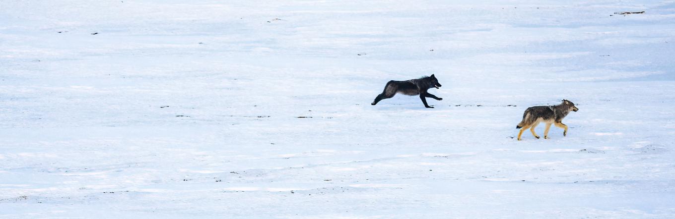
Coyote or Gray Wolf: How to Spot the Differences
Gray wolves are about twice the size of coyotes. They can measure up to 6 feet in length, including tail, and stand approximately 30 inches in height at the shoulder. Female wolves weigh 70–80 pounds, while males weigh around 95–100 pounds.