How can I download the COTREX trail app?
What makes the COTREX app different from other trail apps?
Over three years in the making, COTREX apps utilizes data from 230 land managers making it the most comprehensive map of trails in Colorado.
Who can use the the COTREX app?
COTREX is for everyone – hikers, bikers, ATV riders, equestrian riders, wheelchair users and others.
Is the app free?
Yes! The Cotrex app is free to use.
Do I need to have an account to use COTREX?
No, you do not have to have an account to use the basic functions of the COTREX app. However, you do need an account and be logged in if you want to post content to COTREX (such as saving a route).
Can I use the COTREX app offline?
Yes! You can download offline maps to navigate trails when you don’t have cellular service.
How does COTREX compare to other Colorado trail apps?
While we have built what we think is a robust tool including most features land managers and the public want, there still may be locally desired features that may not be addressed in COTREX. For instance, the Crested Butte/Gunnsion trails app (CBGTrails) integrates with Strava. CBGTrails held a trailquest race to see which local could bike all trails in the Gunnison Valley trail system the fastest (Spoiler: this lady won).
The trail near my house isn’t on COTREX. Why?
The trail near your house might not be on COTREX for a couple reasons:
How can I get the trail near my house on COTREX?
Work with your land manager to find out if the trail is a legal route or if it isn’t on COTREX because of capacity issues. If the latter, please work with your land manager and have them contact Natural Atlas, the contractor who built COTREX, at COTREX@state.co.us. If the trail is not a legal route, it will be entirely up to your land manager to decide if it should be inventoried or not. Be aware that inventorying a social trail generally involves environmental and planning reviews in addition to mapping its alignment. Your land manager may decide that it’s in the best interest of the property and the agency to not incorporate the trail into the system.
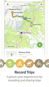
You may also submit map feedback directly by right clicking the map on the web or tapping the green plus button on mobile apps. Please provide as much detail as you can about what's missing or incorrect as well as contact information so we may request clarification if required.
Are winter trails available on the app?
Currently there are no winter trail uses on COTREX, but the state is looking into adding this feature. That said, you can visit the land manager’s webpage to see if they have their own winter maps or allow year-round use on their trails.
What counts as a “trail” in COTREX?
A recreational trail is a common route legally traversed by the general public utilized primarily for recreational purchases. An urban road can be considered a trail if it provides important connectivity to a larger route, or, if it has dedicated bike facilities.
Does the app have any challenges or games?
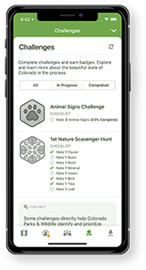
Yes! Users can complete “challenges” to earn badges. For instance, there is a Colorado state wildflower challenge where users must “note” (record in the app) one Colorado Blue Columbine in order to be awarded a badge.
Will more features be added to the app?
Pending funding and other resources, the state is considering adding in stewardship projects and other local alert functionality.
How can I suggest new featured routes?
Fill out our online form to suggest a new featured route. Please keep in mind that the COTREX team will consider other nearby featured routes, level of detail, and land manager approvals before any suggested routes are published.
How will COTREX user data be used?
Users can submit map feedback about trails or note trail obstacles such as downed trees. We use this data to improve trail information as well as inform app management and maintenance decisions
How will the data be maintained and updated over time?
We work to continuously improve trail information as we receive it, and as it is approved for publication by our land management partners. We work directly with our partners to ensure we only display approved and official trails, so the update frequency will vary on a case-by-case basis.


