Elk Hunting in Game Management Unit 45
So You're Looking to Hunt in GMU 45
by Kenny Marcella
 This unit holds good quality elk, and has provided several good bulls over the years for me and my family. In this article, I will provide an overview of the unit, describe some access routes, terrain and potential areas of interest the reader might find in early scouting. The unit is not for everyone; steep drainages, winding trails and switchback roads are common. Go find a good map of the unit, a pencil and paper and let’s get started.
A Bit of History
The unit holds some very special qualities and includes the land where the famous 10th Mountain Division trained for World War Two. The Army chose the area because the terrain was similar to parts of the European Alps. Camp Hale Army Base (named after General Irving Hale), was built in 1942, as a winter training post for the US Army, at a cost of $30 million. At its peak it had 16,000 soldiers; 14,000 of them were part of the 10th Mountain Division. In 1943 it held 14,000 troops, and had the facilities of a small city complete with barracks, mess halls, a small hospital, chapel, fire station, general store (Post Exchange), stockade, ski shop, bakery and even an ice making plant. In 1945 it was deactivated and in 1965 the 'town' dismantled and deeded to US Forest Service.
Unit Boundaries
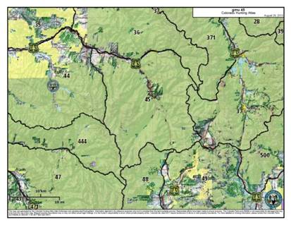
 GMU 45 straddles both Eagle and Pitkin Counties bounded on the North by the Eagle River, East Lake Creek to Dowd Junction, I-70 from Dowd Junction to the Eagle River-Ten mile Creek Divide; on the East by Eagle River-Ten mile Creek divide; on the South by Continental Divide; on the West by the Chance Creek-North Fork Frying pan/Cunningham Creek Drainages and the Cross Creek Homestake Creek Drainages, and to the East is Lake Creek.
If you look in the back of the CPW Big Game brochure, you will find the descriptions of all of the GMU boundaries. It is important to read the boundary descriptions each year to be aware of any unit boundaries that may have changed.
Access to the Unit
There are several access points to get into the unit. A look at the map shows several major highways if you are coming from the East, you can take I-70 all the way to the Minturn exit and head South on US Highway 24. There are several very good roads you can follow into the unit just outside of Minturn. You cross over into the unit shortly after leaving I-70. On the right as you head South is Meadow Mountain (an old ski area decommissioned when Vail started to take off). If you want to pack into the area, there is a pull out on the West side of the road about two miles from I-70 (I have seen elk right from the parking area). You can either hike up that portion of the unit or take pack animals; read the rules on pack animals in this section of the unit.
Instead of turning early, you can drive through Minturn heading South, you will come up on several roads on the West side, which will lead to some very good areas to hunt elk. There is public access on many of the roads in this stretch of highway. If you keep driving South on US 24, you will pass a huge tailings pile on the right that has been reclaimed from the old mining days. Just as you pass it you will see a sign and road to the right that will take you into Tigawam Park. This is a favored area of the local hunters as it's so close to home.
Heading South
If you would prefer to get farther up in the high country, keep heading South on US 24 to the Gold Park Campground. Turn off about 4 miles past a very scenic bridge (which goes to Redcliff). If you travel up the Gold Park road (also called Homestake Road and eventually leads to Homestake Reservoir, which is discussed in the "Climbing Higher" section below), you will find many areas where you can pull off the road and camp. The trailhead to Whitney Lake is a good starting point for many hunters... either on horseback or on foot. There is no road into this area, but you can hike around the aspen groves and find elk scattered throughout the entire east-facing slope at times. If you feel like you want to hunt in dark timber (or if it is warm), you might have to do that.
Driving further up the road to Missouri Creek, this is the beginning of the road that takes you up to Mount of the Holy Cross City. Holy Cross is an old mining town and some of the old buildings are still up there above timberline. I have harvested several nice bulls out of this area.
Climbing Higher
If you still want to go higher in elevation (the 2nd and 3rd seasons can get some substantial snows, so be prepared). Be sure to take shovels, chains, and are properly prepared if you get stuck. In my experience, I stayed on the main road with my vehicle and was able to get out and to the bottom with no problem. This middle section of the unit is the most challenging as far as the amount of hiking and climbing involved and there is very little road hunting (in the overall unit) as it's cradled by Wilderness Area. See Elk Hunting University's "Wapiti Workout" for tips high altitude hunting. The end of the Gold Park Road leads you to Homestake Reservoir: this is a water retention lake that collects water from the Western Slope and pipes it to Denver/ Front Range. On good years when the snow is not to deep, this can be a very good camping site. The elk are and will be all around you, but you will still have to go out and look for them, as they are pretty reclusive. When you do find elk... they are usually in groups of 6-20. I have noticed when it snows they tend to cluster together more. I have seen groups of 50-70 with several nice 5x5 (and up) bulls.
Back to the Highway
 Back down to US 24 and heading South again, there are additional access points. I won't go into too much detail, but will explain about where access is and what to expect. As you continue South you will head up a hill and will see the "S" curve just as you enter the highway again from Gold Park/ Homestake road. Keep your eyes peeled, there could be elk on this "S" curve (I have seen them there many times). Still heading South, the next public access road is No Name Road (it will be to your right). Just about anywhere on this 6-7 mile long road you can run into elk from the camping spot on the bottom, to the end of the road on top.
Continuing on US 24 South for about three miles, you will see the main Gate to Camp Hale off to the left. This would be a good pace to stop and take a break. The scenery is beautiful and the gate stands testament to the 16,000 Army troops that had been trained there only 60 - 70 years before.
Looking to the East, you will have three main access points to think about from this location: to your left you have Horn Silver Mountain, and McAllister Gulch, in the middle there's Resolution Creek Access, and to the right will be Hennesy gulch, Cataract Creek, Ranch Creek. Some of the South portion of this area closed off to public as there where unexploded ordnance found a couple years back and access was closed to ensure public safety. Check with the Forest Service for access advice.
Hornsilver/McAllister Gulch
The road can be difficult if there is snow, and about three miles in the grade of the road gets very steep. It can be a bear trying to stay on the road when the snow gets deeper than 10 inches. Keep this in mind as there are not many places to turn around or pass by another vehicle when traveling up McAllister road. The elk will be in the high tops near the cliffs in the early morning and in the trees after 8:30 a.m.
Resolution Creek/ Ptarmigan Pass Road
This road is a good road all the way to the top of Ptarmigan pass. Heading East up Ptarmigan Pass road will lead to some very good areas near the Wearyman side of the pass. It drops into Wearyman and comes out on Shrine Pass (near the top of Vail Pass). This is a great elk area, but still I would not drop off the top heading East if there is any snow. It will be a huge tow bill to get you out come next spring.
If you choose to take the road to the right off Ptarmigan road (to Pearl Creek and North Pearl Creek) rather than heading up to the passes, be prepared for some rough 4WD road again if there is snow. You can also park and climb up the ridge, if you want to hike a while.
Additional Areas
 We have covered the main access points from I-70 and US 24, but there are some additional areas to hunt that are worth noting.
Tennessee Pass
If you head South on US 24 to the top of Tennessee Pass (the Southern boundary of GMU 45). Both the right and left side of the road are generally open areas to hunting. There are some areas that are private (they are usually very well marked, but be sure to have a map). If you'd like to hunt on private land, you must obtain written permission from the landowner whose property you'd like to hunt on.
Redcliff to Shrine Pass
There are additional areas from Redcliff back to Shrine pass. There is some good hunting in this area, but this area is mixed in with private land and is also popular hunters.
Camp Hale Cont
If you would like a good hunt relatively free from other hunters, you could camp at one of the Camp Hale campgrounds (to the right of the main entrance, just follow the signs). After Labor Day, they turn off all the water to the faucets and some of the bathrooms may be locked, but the actual campsites are still open. Hunting access is a relatively short distance from here: Head West from the main entrance and you will encounter a hill (go straight up it). Slowly walk up until you get above the old railroad lines, and you will be in good elk country from the first 1/4 mile in. From here access to Camp Hale Pond Lake, Yoder gulch, or Rule Gulch are all possible. Just remember this area is high altitude and you are hunting at about 11,000 feet where the oxygen is pretty skimpy.
Access from Eagle, Avon and Vail Pass
There are some other access points from near Eagle, Avon, and on top of Vail Pass, but are not recommended for novice hunters. These areas will require detailed knowledge of the area terrain and game movement and endurance, determination and patience to be successful. At present you can still drive up all the main roads in the bottoms, with either an ATV or 4X4, and yes you will need 4X4 in the last two- three seasons to get past the snow!
Final Thoughts
My father drew one of the first 25 elk tags in this unit and my family has continued to hunt in GMU 45 for the past 40 years. We have harvested many bulls and cows; you just have to hunt and hike a bit to get the job done. If there is one thing that we always talk about in our family, it is how beautiful and special this country is. There's Camp Hale where the 10th Mountain Division trained for combat, the Mount of the Holy Cross, and nearby is one of the most beautiful ski and resort areas in the world.
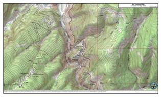
Note: The article above was written to assist hunters with a description of the unit and some of the access points for hunting. Road closures, changes in USFS policy and real estate ownership can occur at any time. It is the responsibility of the hunter to verify the information provided above and understand the article is meant as a guide to begin the process of personal scouting. The map inserts were taken from the Colorado Parks and Wildlife Hunting Atlas.


