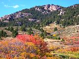
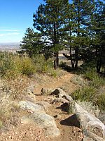
 From rolling valleys to mountainous hillsides, Lory State Park's 26 miles of trails rarely exceed a 12 percent grade. The variety of trails makes the park suitable for short or long hikes, mountain bikes, horseback riders and joggers. Safe drinking water and restroom facilities are not available on the trails. An adequate water supply should be carried and may be obtained near the park entrance.
View the Lory State Park trail map.
Permitted uses: Foot only
Miles paved: 0
Miles non-paved: 1.7
Total distance: 1.7
Usage: Medium to High
Degree of difficulty: Moderate to Difficult
Elevation: 5,600
ADA accessible: No
Pets: Yes and must be under control and on a leash not exceeding 6 feet in length.
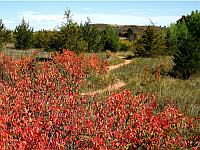
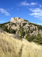
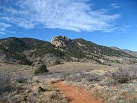
Comments: This 1.7-mile hiking trail winds through forested mountainsides and open meadows to the summit of Arthur's Rock. Upon reaching the summit of Arthur's Rock, hikers are rewarded with a breathtaking view of Horsetooth Reservoir and the Front Range from an elevation of 6,780 feet.
Read a photo-essay walkthrough of Authur's Rock Trail, or watch a video.
 Timber Trail
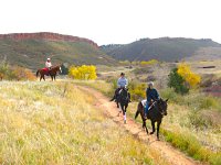
Permitted uses: Foot, expert horse and expert mountain bike
Miles paved: 0
Miles non-paved: 3.7
Total distance: 3.7
Usage: Medium
Degree of difficulty: Moderate to Difficult
Elevation: 5,600
ADA accessible: No
Pets: Yes and must be under control and on a leash not exceeding 6 feet in length.
Comments: This 3.7-mile trail ascends from the Group Picnic Area to the ridge behind Arthur's Rock. The trail climbs steeply through grass and shrub lands, leveling off in the pine forest, where the park's six primitive backcountry sites are located.
 Well Gulch Nature Trail
Permitted uses: Foot only
Miles paved: 0
Miles non-paved: 1.5
Total distance: 1.5
Usage: Medium to High
Degree of difficulty: Easy to Moderate
Elevation: 5,580
ADA accessible: No
Pets: Yes and must be under control and on a leash not exceeding 6 feet in length.
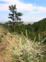
Comments: Wildflowers, steep rock walls, and wetland vegetation line this plush 1.5-mile trail. A self-guided nature tour takes you through the grasslands, mountain shrub and timber life zones, with stations along the way, illustrating botany, geology and animal life in Lory State Park. Watch a video of Well Gulch Nature Trail.
 East Valley Trail
Permitted uses: Foot, horse, and mountain bike
Miles paved: 0
Miles non-paved: 2.2
Total distance: 2.2
Usage: Medium to High
Degree of difficulty: Easy
Elevation: 5,580
ADA accessible: No
Pets: Yes and must be under control and on a leash not exceeding 6 feet in length.
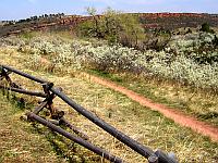
Comments: East Valley trail is a popular horse and mountain bike trail that stays at nearly the same elevation. When used with the West Valley trail, it provides a nice loop trail of approximately 5.5 miles. These trails run parallel to the main road, branching to coves at Horsetooth Reservoir or meeting with the mountain trails.
NOTE: All users yield to horseback riders and bicyclists yield to all trail users
West Valley Trail
Permitted uses: Foot, horse and mountain bike
Miles paved: 0
Miles non-paved: 2.3
Total distance: 2.3
Usage: Medium to High
Degree of difficulty: Easy
Elevation: 5,600
ADA accessible: No
Pets: Yes and must be under control and on a leash not exceeding 6 feet in length.
Comments: West Valley trail is a popular horse and mountain bike trail that stays at nearly the same elevation. When used with the East Valley trail, it provides a nice loop trail with bridges and scenic views.
NOTE: All users yield to horseback riders and bicyclists yield to all trail users
 Mill Creek Link Trail
Permitted uses: Foot, horse, and mountain bike
Miles paved: 0
Miles non-paved: 0.9
Total distance: 0.9
Usage: Medium
Degree of difficulty: Difficult
Elevation: 5,600
ADA accessible: No
Pets: Yes and must be under control and on a leash not exceeding 6 feet in length.
Comments: Mill Creek Link trail provides access for hikers, horseback riders, and mountain bikers to the Mill Creek trail in Horsetooth Mountain Open Space (operated by Larimer County Parks). From the south valley trail, this link offers passage to the upper elevations of Horsetooth Mountain Open Space via the Mill Creek Trail.
NOTE: All users yield to horseback riders and bicyclists yield to all trail users
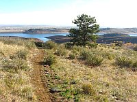
 Shoreline Trail
Permitted uses: Foot, horse, and mountain bike
Miles paved: 0
Miles non-paved: 1
Total distance: 1
Usage: Low
Degree of difficulty: Easy to Moderate
Elevation: 5,600
ADA accessible: No
Pets: Yes and must be under control and on a leash not exceeding 6 feet in length.
Comments: This comfortable one-mile hike leads down to the edge of Horsetooth Reservoir. The red sandstone hogbacks offer a striking background to the grassy meadows where deer graze.
 Overlook Trail
Permitted uses: Foot only
Miles paved: 0
Miles non-paved: 1.2
Total distance: 1.2
Usage: Low to Medium
Degree of difficulty: Moderate
Elevation: 5,800
ADA: No
Pets: Yes and must be under control and on a leash not exceeding 6 feet in length.
Comments: Mule deer, wildflowers, Abert's squirrels, and spectacular views of the eastern plains can be seen along this 1.2-mile trail, connecting Arthur's Rock Trail to the Well Gulch Nature Trail.
 Westridge Trail
Permitted uses: Foot, horse, and mountain bike
Miles paved: 0
Miles non-paved: 1.5
Total distance: 1.5
Usage: Low
Degree of difficulty: Moderate
Elevation: 6,700
ADA accessible: No
Pets: Yes and must be under control and on a leash not exceeding 6 feet in length.
Comments: Following old jeep and fire roads, this 1.5-mile trail takes you along the west border of Lory. Tucked down in the pine forest broken by wildflower-filled, open meadows, it's easy to forget about how close you are to civilization.
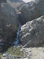 Waterfall Trail
Permitted uses: Foot Only
Miles paved: 0
Miles non-paved: .1
Total distance: .1
Usage: Minimal
Degree of difficulty: Easy
Elevation: 5,600
ADA accessible: No
Pets: Yes and must be under control and on a leash not exceeding 6 feet in length.
Comments: This 0.1-mile trail leads back to a series of waterfalls (during the spring and early summer). Wetland vegetation can be found along the trail throughout the summer.
 Howard Trail
Permitted uses: Foot, expert horse and expert mountain bike
Miles paved: 0
Miles non-paved: 2.1
Total distance: 2.1
Usage: Medium
Degree of difficulty: Moderate to Difficult
Elevation: 6,400
ADA accessible: No
Pets: Yes and must be under control and on a leash not exceeding 6 feet in length.
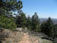
Comments: This 2.1-mile trail winds through forested mountainsides and an open meadow to intersect with the Timber Trail near the summit of Arthur's Rock. The views to the east overlooking Horsetooth Reservoir and the City of Fort Collins are spectacular.
 Kimmons Trail
Permitted uses: Foot, horse, and mountain bike
Miles paved: 0
Miles non-paved: 1.1
Total distance: 1.1
Usage: Low to Medium
Degree of difficulty: Easy to Moderate
Elevation: 6,000
ADA: No
Pets: Yes and must be under control and on a leash not exceeding 6 feet in length.
Comments: Spectacular views of the eastern plains can be seen along this 1.1-mile trail, connecting Timber Trail to the West Valley Trail.
 South Valley Trail Loop
Permitted uses: Foot, horse, and mountain bike
Miles paved: 0
Miles non-paved: 2.7
Total distance: 2.7
Usage: High
Degree of difficulty: easy
Elevation: 5,400
ADA accessible: No
Pets: Yes and must be under control and on a leash not exceeding 6 feet in length.
Comments: This easy 2.7 mile loop trail takes you to the south border of Lory State Park. This link offers an easy transition into Horsetooth Mountain Open Space.


