South Park, where both Eleven Mile and Spinney Mountain State Parks are located, is a land of magnetic charms – rich in beauty, sparkling rivers, wildlife, mineral wealth, range land and legend. The immense upland valley is located in the geographic center of Colorado. It is a large plateau occupying approximately 900 square miles, varying in elevation from 8500 feet to 10,000 feet above sea level.
Prehistory
The cultural history of Eleven Mile State Park probably began about 12,000 years ago. Archaeological evidence recovered from surveys in portions of the park indicates that the Folsom, Plano, Archaic and Woodland prehistoric cultures are all present. As early as 1000 A.D., the Ute Indians occupied the area and remained here for several hundred years. The most common archaeological sites in South Park are temporary campsites which were probably used by the Ute Indians during summer and fall hunting. Ideal for a people who were hunters and gathers, the area supported an abundance of buffalo, antelope and fish. Vegetation included cactus, yucca, strawberries and dozens of other edible plants.
Recent History (1500-1900 A.D.)
 The earliest year-long inhabitants of the area were the Ute tribes who found an abundance of wildlife here. The intrusion of the Spanish and French explorers in the 1500’s caused the Utes to leave the area temporarily; resettling here during the late 1600’s after the initial quest for gold was ended. These same European explorers are reported to have crossed the area in the eighteenth century.
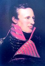
In 1806, President Thomas Jefferson sent Lieutenant Zebulon Pike with 21 men to explore the South Park Area. After a failed attempt at climbing what is now called Pikes Peak, Lt. Pike entered South Park just east of where Eleven Mile Reservoir now lies, and then advanced west. He then climbed an elevation which was probably Spinney Mountain. Pike’s 1806 journal provides the first clear evidence of Anglo-European influence in the area. However, it took another 50 years before that influence made an impact.
By 1859, the first mining era began with the re-discovery of gold in the northern and western portions of South Park and the Utes were once again forced to leave their favorite hunting grounds. This gold discovery created a dramatic population boom with Eleven Mile Canyon being primarily used as a transportation route, but South Park also supported ranching, timber harvest and the fur trading businesses.
Between 1861 and 1870, nearly 11,000 miners converged upon South Park and established permanent settlements, one of which was Fairplay. Today, Fairplay is the county seat of Park County and is one of only a few mining towns from that era to survive.
Once called Granite Canyon, several towns sprouted in the Eleven Mile Canyon area. Idlewild, Freshwater and Howbert were all former towns that became inundated by water when the reservoir was built. Howbert, the biggest of the three, was named for Colorado Springs banker and Midland Railroad investor Irving Howbert. At one time, the town of Howbert consisted of a telegraph office, post office, grocery store, drugstore, butcher shop, hotel, two saloons, sawmill, depot, schoolhouse, cemetery, 25 houses and a 42-car capacity passing track for the railroad. Numerous ranches also surrounded the town. Both lumber operations and ranching provided jobs for many of the town’s residents, however some townsfolk went to work in the mines at Cripple Creek. The influx of people led to the establishment of many trails and wagon roads that then provided a logical route for the railroads to follow as well.
Turn of the 20th Century
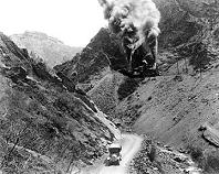 Population growth made it profitable to open the Colorado Midland Railroad in 1887. It was the first broad-gauged line into the Colorado Rockies. With the coming of the railroad, ore was capable of being transported in mass quantity from the South Park mines to the smelters in Colorado Springs. The Midland also provided jobs and other economic advantages, since passengers and shippers were given easy access to Leadville, Aspen and other mining towns. In addition, the railroad transported visitors from Colorado Springs to what is now Eleven Mile Reservoir so that they could enjoy the numerous wildflowers that grew along the banks of the South Platte River. The “wildflower excursions” followed a route from Colorado Springs, through Eleven Mile Canyon, to a spot near Spinney Mountain, where it turned around and proceeded back to Colorado Springs. This was a very popular tour for the affluent society of Colorado Springs around the turn of the century and meant that the Midland had a direct influence on the rapid growth of the tourist industry in Southern Colorado.
But the Midland had been expensive to build, difficult to operate and disappointing financially. With competition from both the Union Pacific and the Denver & Rio Grande Railroads, the Midland was in trouble from the beginning. According to the book, Bayou Salado by Virginia McConnell Simmons, “WWI spawned government control of the railroads with the result that all through traffic was assigned to the Denver & Rio Grande.” The Midland was dismantled soon after in 1921 and the highway over Wilkerson Pass was rerouted to the “old” Midland Railroad bed through the middle of Eleven Mile Canyon and what is now the middle of the reservoir.
Just after the turn of the century, the rapidly growing City of Denver began to seek back up water sources. Many sites were considered over a period of years. In 1926, survey work for the proposed dam began and in 1932, the Eleven Mile Canyon Dam was completed and heralded as an “engineering triumph.” Construction of the dam began in 1930 and was completed just two years later in 1932. Eighty men worked on the original dam project, living in a camp about 1000 feet down the canyon from the dam site. Three hundred thousand sacks of cement were used to make 50,000 cubic yards of concrete for the original dam structure.
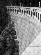 The dam was built upon a series of stair steps cut into the surrounding rock wall and rising 147 feet high above the bedrock. Because of this, the canyon walls hold the weight of the water, not the dam itself. When completed, the Eleven Mile Dam created the largest, artificial body of water in Colorado at that time. An extension to the spillway was added in 1957 which brought Eleven Mile’s bulk capacity to 97,779 acre feet of water. Meanwhile, the highway, running through the middle of the canyon and the proposed reservoir, was re-routed once more and moved back to its present location over Wilkerson Pass.
The Denver Water Department owns the dam, the water and most of the land that surrounds the reservoir. Eleven Mile is one of seven reservoirs that provide drinking water for Denver and because of the obvious need to protect against pollution, strict regulations prohibiting certain recreational activities are in effect.
The Division of Parks and Outdoor Recreation assumed management of the area in 1960 under a lease agreement with the Denver Water Board.
Today the waters of Eleven Mile Reservoir cover the ranches and towns that once prospered long ago. The water line cut some ranches in two, while others were totally submerged. Surrounding mountains and campgrounds in Eleven Mile State Park have been named after a few of the ranchers whose lands now lies underwater. Howbert cemetery is believed to be on dry land, but has not been located.


